Showing posts with label IOW Coast. Show all posts

Friday, 2 July 2021

02/07/21 - Isle of Wight Coastal Path Summary

Distance - 70 Miles

Geocaches Found - 16


The excellent bus service allows for an easy circuit of the Island through linear walks.  It nicely fits into a weeks holiday, taking 6 days to complete at a not too strenuous pace.

Itinery

Day 1 - East Cowes to St Helens 

Day 2 - St Helens to Ventnor  

Day 3 - Ventnor to Brighstone

Day 4 - Brighstone to Totland Bay

Day 5 - Totland Bay to Shalfleet

Day 6 - Shalfleet to Cowes


Pros

Weekly bus pass available through an app - or a ticket from Newport/Ryde Bus Stations - for around £27.

Bus Service is uniformly excellent and on-time

Newport would be a good place to base yourself, as this is the transport hub.  However, we struggled to find good accommodation there and Cowes/East Cowes provided more options but meant an extra 20 minutes and bus change.

Pubs are geared up for tourists and service/quality was perfect.  A number of Good Beer Guide pubs are on the Coast.  Fuddle Dee Dum beer from Goddards Brewery was the find of the week.

Cons

Southern Side of the Island - from Ventnor, through Freshwater and around to Totland Bay is dull, the coast path is suffering from major erosion and refreshment stops are rather limited.

Roll of Honour

Best Days Walking - Day 2 - St Helens to Ventnore.  Whitecliff headland offered great views and plenty of seaside action through Shanklin/Sandown.

Pub of the Week - Wheatsheaf, Yarmouth.  Lovely courtyard and lovely people running it.  St Austell Proper Job was Pint of the Week.

The Flickr Photo Album

Isle of Wight Coast Path

02/07/21 - IOW Coast Path Day 6 - Shalfleet to Cowes

Distance - 9.5 Miles

Geocaches - 4

Places of Interest - Newtown, Thorness Bay

Previous Stages - Day 1, Day 2, Day 3, Day 4, Day 5


The journey around the Isle of Wight comes to an end.


Fittingly, its an easy day's walking - and Cowes - as it prepares for the "round the island" race - is a suitably buzzing place to finish.  Who wouldn't want to be greeted by a townful of drunken pirates.

Early stages of the walk are circumventing the sprawling Newtown River Creek.  Its road-walking on relatively quiet lanes.  Newport itself has a National Trust Building - the Town Hall - and enough information boards to satisfy the historically curious.  We were more pleased at finding the disabled loos unlocked, even though the attraction was covid-closed.

Newtown River
Newtown River
Newtown Town Hall
Newtown Town Hall

More lane walking into Porchfield, where there was no need to be concerned if we would be too early for the Sportman's Rest Pub.  Hoping its a re-fit, not a re-development.

Sportman's Rest, Porchfield
Will it come back, Lazarus Style?

But its the coast we are here for and its the coast we find at Thorness Bay - marked on the OS Map as "Mud and Sand" - so I won't bore you with photos.  Gurnard Bay is a shanty town of wooden shacks that range from shed-like to mansion.  Civilisation and refreshment opportunities increase with every step, as we approach Cowes from the west.  The first ice cream stand found was not ignored.

Coming into Cowes
Coming into Cowes

We wait for the town to slake our thirst properly.  The Vectis Tavern is chosen simply because has empty outdoor seating.  The more popular Anchor Inn is chosen because its in the Good Beer Guide.

Goddard's Fuddle-Dee-Dum is chosen as a closing drink.  Those who have been to the IOW will know.
 
Vectis Tavern, Cowes
Pub 1 - Vectis Tavern
The Anchor, Cowes
Pub 2 - Anchor Tavern
IOW Coast Path Completers
Suntan, not exhaustion redness.  Empty Fuddle Dee Dum.

To complete the round and join up the walk with exactly where we started, we need to get across the Medina.

The floating bridge provides.  Also doubles as an alarm clock, if you stay where we stayed.

The final stage home.
The machine that clunked us awake every day at 5am


Thursday, 1 July 2021

01/07/21 - IOW Coast Path Day 5 - Totland Bay to Shalfleet

Distance - 9 Miles

Geocaches - 2

Places of Interest - Yarmouth

Previous Stages - Day 1, Day 2, Day 3, Day 4


The longest bus journey of the week to get to the start of the walk.  It's worth it.  After the monotony of a surprisingly bleak South Coast, the quality of the walk improves tremendously.  

We find our favourite place on the whole Island.  Yarmouth is strategically positioned for lunchtime and we find a wonderful boozer.

After learning what normal holiday makers get up to at Colwell Bay, we climb into the shade at Fort Victoria Country Park.  The odd tenement of Fort Albert waving from our side of the water to the "how is there a castle in the middle of the sea" at Hurst Castle.

Colwell Bay
The Normal Holiday Makers in the shadow for Fort Albert
Hurst Castle
Precariously balanced Hurst Castle

Its just before midday when we cross the River Yar Bridge into Yarmouth.  I think to myself "must not stop at the first pub I see" - to peruse whats on offer in an unvisited town before committing.

We walk straight into the wonderful courtyard beer garden that is found at the back of the Wheatsheaf.  

The first pub we see.

It must have been a sixth sense that told me they had both Proper Job and friendly staff who wanted to make sure your visit was a pleasure.   Are you reading Totland's Waterfront?

It was hard to tear ourselves away from a 3rd drink in the sunshine, knowing it would be a highlight of the walk.  Still, we needed lunch - provided by the Market Square's deli and consumed in the pier's shadow.

Proper Job at the Wheatsheaf, Yarmouth
Pint of the Week
The Wheatsheaf, Yarmouth
Pub of the Week
Yarmouth Pier
Lunchtime spot of the week

Exiting Yarmouth, we have more shady woodland walking through Bouldnor Copse and an inland diversion to Shalfleet - to avoid the bridge-less Newtown River.

Once again, the bus stop is strategically located next to a pub but in the cruel irony of the times - the recently re-opended New Inn has had to re-close due to lack of staff.

It could have been the "best wait for a bus" ever.

New Inn, Shalfleet
Bus Stops - IOW Style
Chef Shortage
The Notice of Doom


Wednesday, 30 June 2021

30/06/2021 - IOW Coast Path Day 4 - Brighstone to Totland Bay

Distance - 11.6 Miles

Geocaches - 2

Places of Interest - Freshwater,  The Needles, Alum Bay, The Waterfront (Good Beer Guide Pub)

Previous Stages - Day 1, Day 2, Day 3 


Day 4 on the Coast Path and the Southern Sections changes from crumbling mud cliffs back to the white chalk of Tennyson Downs, which we can see ahead of us for the majority of the walk.  


Crumbling Cliffs of the South
Crumbling Cliffs
P1010631
The Mud Cliffs to be replaced with Chalk Cliffs

I cannot tell a lie - the walking is dull and monotonous.  Seeing the route ahead, we have misguided motivation in Freshwater.  This should be a good place to take refreshments, but the only pub - The Albion Hotel - is closed down.  It was a good job we took advantage of the ice cream van Shippards Chine.
Freshwater Bay
Crystal Clear Sea at Freshwater Bay....
Freshwater Bay
.... Sadly Publess

Its a climb out of Freshwater up onto Tennyson Downs, with the monument a focal point.  A decision needs to be made here.  To complete the Coast Path we need to walk onwards to coastguard cottages and loop back on ourselves.  Alternatively, there is a short cut that could save 3 miles of walking and double the amount of Good Beer Guide Ticks in the day.
Tennyson Monument
Sit down and think about our route

We don't cheat ourselves but the sanity of missing out on Highdown Inn is questioned when we cannot see the Needles from the end of the path.

This is corrected as we pass Alum Bay and look back on the route we have taken.

Alum Bay
Alum Bay
The Needles
The Needles (just about)

Its not far to Totland Bay - but it has been another route march, without a real break.  Our pace only increases when we see the sign to the steps that lead to the Waterfront Inn.

A good beer guide pub that answers the question, what beers do you have on by listing the lagers.  Further prompting reveals 3 real ales, but I'm sure I didn't ask for a Doom Bar.  I definitely did request the iced water.
Waterfront, Totland Bay
A Good Beer Guide Tick
Waterfront, Totland Bay
Doom Bar.  Water Chaser.

We'd read the reviews and seen the complaints from people who weren't allowed to eat on their lovely terrace overlooking the Solent.  It's one of those funny places that seem to have too many rules that are stringently followed by the staff.

We witnessed a group of pensioners getting told off for eating their icecreams purchased from the premises on the wall outside.

Of course, Covid was blamed for this over-officiousness.   


Tuesday, 29 June 2021

29/06/2021 - IOW Coast Path Day 3 - Ventnor to Brighstone

Distance - 13.1 Miles

Geocaches - 4

Places of Interest - Blackgang Chine

Previous Stages - Day 1, Day 2 


There is rather an important football game on tonight.  Bus Times require an early start and a bit of a route march to get to the only return transportation that guarantees being seated in front of a TV at 5pm.

Not that there is much on this stretch of the IOW Coast Path to delay us.  It is remarkably bleak.  The sea fret not helping with things.

Exiting Ventnor provides all of today's geocaches.  A wild camper - in an unfathomably large family tent - is guarding one particular ground zero.  My ferreting at fence posts awakes him and he comes out to pontificate about today's game - claiming to both hate football and be very anxious about the result.  We assure him we are not the tent inspectors and head off - leaving behind some pretty beaches and coves to get up onto high farmland.  We could be walking anywhere.

Out of Ventnor
Coves, just outside Ventnor
High up on farmland
Up on field edges - with the Sea Fret obscuring views

Progress is marked by passing the most Southerly part of the Island - St Catherines Point.  It's that grim a day that the lighthouse is turned on.

St Catherines Point
If I had timed the photo better, you would have seen a flash

Even on a tight schedule, refreshment stops need to be made.  The map has a big blue cup of joy in Shale - but will it be there and will it be open?  Fortunately, the Wight Mouse Inn is operating as a hotel - so once you can find access via a convoluted covid one way system - that has completely flummoxed the pensioners exiting through the in door - we have liquid refreshments at 11:50am.

Chale Church
Shale Church
Wight Mouse Inn, Chale
Back on the road at 12:20pm

The cliffs are regained - along with a confusing notice that they are dangerous and the path is closed but offering no detour or indication of how long the path is closed for.  We press on, hugging the farmers fence and learn the meaning of a "Chine".  It is where water meets the coast and due to the the cliffs being basically made of mud - significant detours have to be made inland to get around them.

Blackgang Chine is the first and most significant - with a family fun attraction that must be closed - judging by the empty car park.

More crumbling coast line
The crumbling mud cliffs of South Isle of Wight

A less significant detour is met at Whale Chine and finally, at Shepherd's Chine - the coast path disappears and we give up on it. 

We know that we will have to come inland to reach the bus stop at Brighouse at some point - so this seems as good a point as any.

The next 2 miles is a lane based trudge that could put you off walking for life.

We arrive at the Three Bishops Pub at 2:40pm, meaning we have 20 minutes to convince the surly barkeeps that we deserve a drink before the bus on the hour.  Three inquires, and eventually we are served by the cleaner.  The real bar staff more interested in putting up (or taking down) St George's Cross bunting.

Three Bishops, Brighstone
Surly service at the Three Bishops

Not a huge amount to recommend the walk but we met our goals and despite everyone in Newtown clocking off work early for the game and clogging up the roads - we get back to our accommodation for 4:40pm.

Mrs M luxuriates in the bath, the game kicks off and then the boiler explodes.  A cascade of water gushing from the bottom, I charge around trying to simultaneously find receptacles and read the manual to find the stop cock is located.

The emergency plumber was delighted to get a call 20 minutes into the game.

He turned up 5 minutes after the final whistle.  Informing him we had beat the Germans in a competitive game for the first time in 55 years didn't cheer him up as much as I would have expected.


Monday, 28 June 2021

28/06/21 - IOW Coast Path Day 2 - St Helens to Ventnor

Distance - 13.6 Miles

Geocaches - 1

Places of Interest - Bembridge Harbour, Culver Down, Sandown/Shanklin

Previous Stages - Day 1


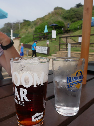
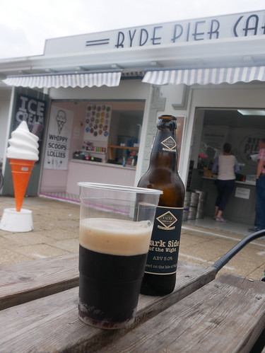
The bus journey from East Cowes to St Helens involved a change over at Ryde, providing just enough time for bacon sarnies at the Pier Cafe.  We couldn't have started the walk in higher spirits.

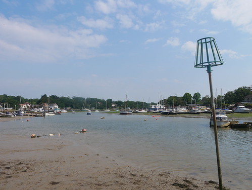
Alighting at St Helens, we drop down to the sea along a residential street and navigate Bembridge Harbour.  The tide is out and there are are a collection of House Boats to admire.

Bembridge
Entering Bembridge - with the tide out
House Boats at Bembridge
One of the many house boats

Once we turn left at the Pilot Inn, we are walking on the sand for the first time at Bembridge Life Boat Station.  

Bembridge Lifboat Station
A half mile of Sand Walking - at Bembridge Life Boat Station

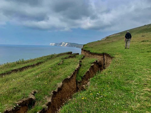
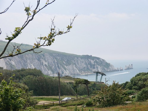
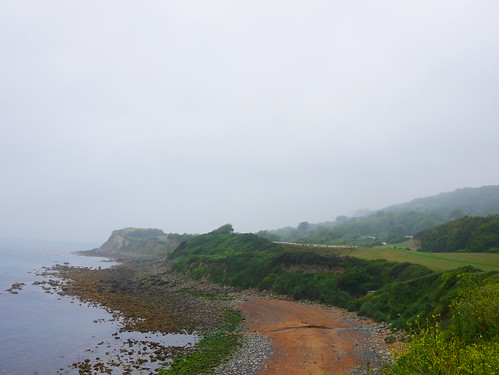
A climb back onto the Coast Path, which provides us a sneak preview of a scene that will dominate the walk.  Whitecliff, Culver Down and its monument.  It marks the furthest East point on the Island and the point where the white chalk gives way to geology that can be only described as "Mud", running the length of the Southern coast line.  We'll discuss this more on day 3's blog - as frankly, there is very little else to discuss.

Even the more solid chalk does not stop erosion and we have our first Path closed sign of the week.

Whitecliff
A first peak at Whitecliff and Culver Down
Path Closed
But we have to determine how to get there.

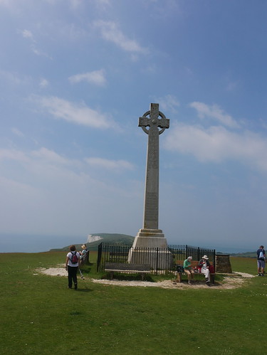
A re-route for about 1/2 mile of road walking and we are back on the path to Culver Down - where the OS Map reveals a Big Blue Cup of Joy and a couple of Northerners coming the other way inform of an Ice Cream Kiosk that takes card.  

Whitecliff
Getting Closer to Culver Down
Culver Down
What we have walked today (so far)
Culver Down Monument
The Monument

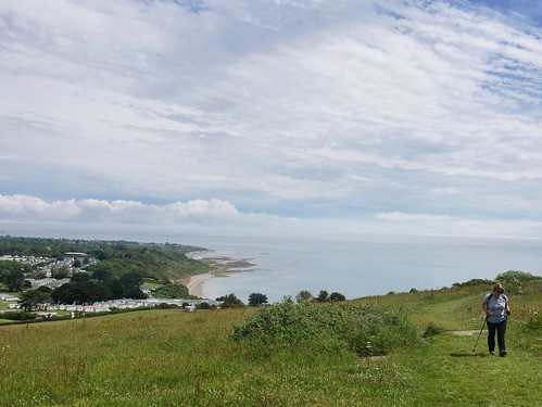
Monday is the day when many of the island's pubs are closed - so we have to make do with a Mr Whippy for the day's first refreshment.  Once we are around the head, we can see Sandown Bay and are reasonably sure that we'll find something more liquid below.

Sandown/Shanklin
That's the Route Ahead - Sandown Bay and around that distant head

Naturally, I have the Island's Good Beer Guide Pubs all marked on my GPS.  Sandown has the first on route - a back-street boozer called the Castle Inn.  The bible describes it as hosting a crib and darts team and a TV that is only turned on for special events.  

Asking Mrs M to check its opening hours are pointless.  As soon as we start along the promenade, we find a rather wonderful Beach Bar in prime position.  She tells me to "stuff my old man's pub, we're stopping here".

Driftwood, Sandown
To be fair, it made sense in the sunshine.

Its impossible to tell where Sandown ends and Shanklin begins, but we battle the proper holiday makers past the pier and the lift and find another pub at Shanklin Chine that is just too good to ignore.

Fishermans Cottage is a thatched roof pub hidden away in the woods that reach the shoreline.  It would have been rude to pass-by - especially as the Coast Path led us to the door.

Fishermans Cottage, Shanklin
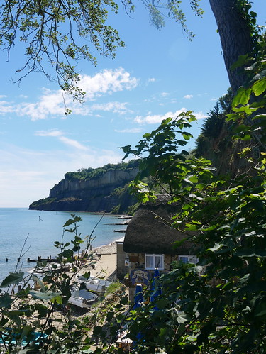
Fisherman's Cottage - for Adnams Ghost Ship

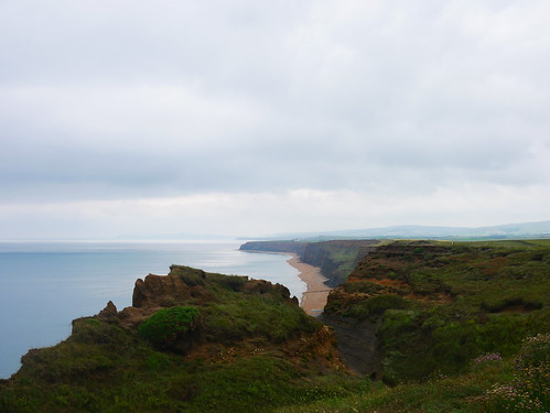
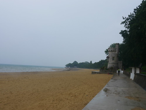
We're hitting the double digits for today's miles and the stretch to Ventnor is one to forget.  The clue is in the name on the map - "The Landslip".  There are diversions aplenty and we reach Ventnor through the undeniably pretty Bonchurch that I would like to say was worth the extra height climbed.

The views were certainly nothing to write home about - but at least there was none of yesterday's mud.

The Landslip
The Landslip

We're rather done in by the time we reach Ventnor - but on entry to the town, I spy the Volunteer... the 2nd of today's potential Good Beer Guide Ticks.  One of the smallest pubs on the Island, the front door is open but only for the landlord to tell us "sometime in July, dependent on Boris".

Fear not - There are two Good Beer Guide entries in Ventnor.

The Volunteer, Ventnor
One for the Dubious Pub Tickers Committee - the threshold was crossed

With negotiation skills that could have got me a job with ASLEF in the 1970's, I have to convince Mrs M that walking past the bus stop - all the way to the far end Ventnor's promenade was worth it.

This is where the Spyglass Inn lives.  What I didn't know then was there would be a queue at 4pm on a Monday.  Don't holidaymakers have their tea at funny times?

The Spyglass Inn, Ventnor
The Spyglass Inn - and the queue.  We were too tired to go elsewhere

Things were stacked against its inclusion.  

  • Obviously a tourist pub.  You can't imagine locals queuing outside for a pub.
  • Not many Good Beer Guide entries are guarded by a Plastic Pirate
  • It's a Marstons House

After a 20 minute wait - we were shown to a shady table with the expected views.  The staff were superb, treating us well and the beer - a reasonable Ringwood Forty-Niner - came as frequently as a man that walked 13 miles in the summer time could demand.

The food was exceptional.

Now to get those legs going to get back to the bus stop.


Sunday, 27 June 2021

27/06/21 - IOW Coast Path Day 1 - East Cowes to St Helens

Distance - 12.3 Miles

Geocaches - 2

Places of Interest - Quarr Abbey, Ryde


The latest adventure - an island circuit.  If the trip involves a ferry crossing, I can class it as a holiday abroad.

We're based in East Cowes - literally 200m from where the Red Funnel docks.  I can hear the cars clunking as I blog.

The Isle of Wight Coast path has the first sign right outside our front door.  8:30am, we head off for a mixed bag of walking and weather.

East Cowes Coast Path
Blue waymarkers outside our gaff, providing the week's navigational hand rail

The start really questions the sanity of this project. We are following the coast path signs, but the roads past Osborne House and through Wootton provide no views of the sea.  The stretch through Wootton actually takes you through some lock up garages in a housing estate.  Odd, but we are early into the journey and optimism is high.

Osbourne House - offering no views
No pictures of lock up garages and as close to Osborne House as we get

Things improve at Fishbourne, as we climb Kite Hill and pick up a path that is at least near the sea at Quarr Abbey.

Wootton Creek
Wootton Creek - Nearly the Sea
The Pigs at Quorr Abbey
The pigs (and piglets) of Quarr Abbey

Ryde is ahead and the pier provides the first chance to have a break.  A handful of mods have parked up their vespas - presumably early for the next bank holiday festival.  The Pier Cafe lures us in with its chalk menu promising "draught beers". San Miguel is a bit too Euro Fizz, so I stick with the bottled Yates Dark Side, having yesterday discovered the brewery at our first Good Beer Guide Pub Tick on the Island, the Lifeboat.

First Pint of the IOW Path - Yates Dark Side
Yates Dark Side at the Ryde Pier Cafe
Esplanade
Leaving Ryde in the Rain

Refreshments finished, we head off just as the heavens open in a downpour.  A ringside view of that most traditional of British Holiday scenes, the families rushing to pack up belongings to get shelter.

And its shelter we find, at a hut we share with a man whose circumstances intrigue.  10 weeks, he has has been here and according to him, it's rained every day.  We wonder what sort of man spends 10 weeks in a hut in Ryde, as we leave him to it and continue along the seafront, all the way to the next town.

Mrs M enquires as to what town it is and my map says "Seaview", which she says sounds like a B&B rather than a town.  A couple of handsome pubs, with enviable views, but alas, its deemed too soon since Ryde to stop at either the Boat House or the Old Fort.

Seaview leads to Seagrove Bay, where the first navigational decision needs to be made - and of course, we make the wrong choice.  My GPS route would have us heading inland at the Southern End of the Bay.  The blue signs indicate that we continue on the sea front.  We do, and we are faced with the mud bath that is Priory Woods.  A handy sign about a 1/2 a mile after this decision point tells us that its steep, muddy and should only be attempted by people correctly attired.  Salt is rubbed into the wound by suggesting a more pleasant path can be found inland.  My originally planned route.

Heading into Priory Woods
Sticking to the coast, for the mud at Priory Woods

We are in a bit of state, by the time we reach the Vine in St Helens - handily positioned to provide refreshments, whilst waiting 40 minutes for the next bus on a Sunday.  But they don't mind - a fine secret garden keeps us off the carpets and they have adapted to the new normal.  Each table in the garden has a little doorbell to call for assistance.

Surprisingly, 60 seconds after pressing a waitress comes to take our order - where the real ale choice is Doom Bar.  Great to see a system working.

And the bus was bang on time.

The Vine, St Helens, With Bus Stop
Mrs M telling other ramblers about the mud