The London they knew is gone, long gone
A
pub crawl inspired by a rather wonderful book (available for free on the Internet Archive) about a pub that named an area. The Fitzroy Tavern.
It documents the glory days of London's drinking dens - from the 1920s to 1940s - when the artists, poets, bohemians, knighted lords and politicians had to earn their booze. Most of the action takes place in the Fitzroy Tavern but a pub crawl is detailed. Lengthy, it dips into Soho to make the most of an extra 30 minutes of drinking time but incredibly, all the pubs still exist.
It had to be done - but with rules. Half pints only. Not because I am going to the French House. Not because I am counting my units. No, we are at an average of £7.80 a pint and I am living off a pension.
Seeing my daughter the following day she stated "Has it come to this?" - in an attempt to get me to sell out my ideals and re-join the rat race.
The second rule - AI suggested I look for evidence of former patrons, artists and poets.
Strap yourselves in. I'll try and keep the text short but there is much work to be done.
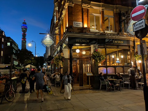
The Fitzroy Tavern, Windmill Street
The natural, obvious starting point. It looks the part of a 1940s, although it is a sympathetic modern recreation. Lots of wooden panelling, multiple rooms and a delightful entrance mosaic. A Sam Smiths pub - seemingly run by a single member of staff both delivering food and manning the bar. This allowed for easy investigation and photo inside, where I was the only sign of life for a good 5 minutes.
AI Rule: Photos of the events described in the book, including the unique charity donations of firing paper money into the ceiling with darts to be collected by a celebrity and to pay for day trips for the poor and/or nutty kids of the area.
Bohemian Rating: 3/5 for looking how it would have been in the period.
 |
| Handsome |
 |
| Richard Attenborough collecting the charity money |
 |
| Lovely |
The Duke of York, Rathbone Street
The author Anthony Burgess is said to have used a gang related incident in this pub in the 1940s as inspiration for A Clockwork Orange. Glasses were smashed and a menacing atmosphere created.
I'd have settled for any sort of atmosphere. I was the only internal customer in a smartly bland McMullens house - who have paid for a marketing firm for a rebranding exercise - with McM's on all their pump clips. It worked, I didn't recognise their beers and nearly ordered one by mistake.
AI Rule: No reference to the past.
Bohemian Rating: 1/5 - soulless.
 |
| Everyone out |
 |
| Pretty Bar - with barhangers discouraged. |
The Newman Arms (Formerly, the Beer House), Rathbone Street
What on earth have they done to this place? Checking my records, I have visited once every 10 years for the first three decades. This is the place that Orwell used as inspiration for the "Proles Pub" in 1984. Oh, the irony! Us proles cannot afford £8 pints. It's had a rather garish makeover in red. The only punters were eating pies in the upstairs dining room. Even the alley used at the start of the 1960s film "Peeping Tom" has had all elements of seediness removed.
AI Rule: A rotating PowerPoint on a TV showing Orwell quotes and images of the past.
Bohemian Rating: 0/5 - Cleaner than a hotel bar.
 |
| Dread in Red |
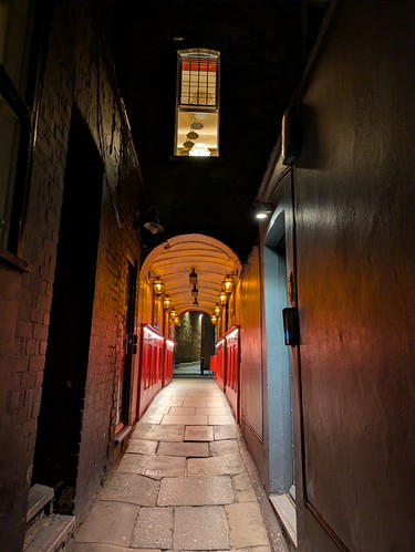 |
| Peeping Tom Alley - in 1995, I was scared to walk down here |
Marquis of Granby, Rathbone Place
How sad that a pub classed as too violent for most of the Bohemian crowd is now an identikit Nicholsons pub. With the exception of Dylan Thomas - who liked to come and fight off duty soldiers who had come cruising. It was also used as a location in the Iris Murdoch Book, Under the Net.
AI Rule: Dylan Thomas references etched as text on the walls.
Bohemian Rating: 2/5 - There were some spectacularly drunk after work office-types.
 |
| Standard Nicholsons |
 |
| When he wasn't fighting and drinking, he was writing |
The Wheatsheaf, Rathbone Place
You manage to go a night without a Nicholson's and then get two in a row. Augustus John brought his then girlfriend, Caitlin Macnamara, here and introduced her to a drunk Dylan Thomas. Come on Augustus, you must have sensed this wouldn't end well. Dylan put his head in her lap, proposed on the spot and they eventually married.
What a chap!
AI Rule: A whole upstairs room dedicated to George Orwell and the "Wheatsheaf Writers"
Bohemian Rating: 0/5 - So dull, I didn't stop for a drink.
 |
| Orwellian in name only |
The Bricklayers Arms, Greese Street
Nestled in a little side street off the main drag, this looked particularly handsome. Short on stories and legend - presumably the Bohemian Set simply had a rule that no watering hole could be passed when gadding about. Another Sam Smiths pub, with a couple of tiny rooms. Looks like I missed out on exploring upstairs.
AI Rule: No references, but they might have been nothing to reference.
Bohemian Rating: 2/5 - In the nicest way possible, the landlady threw off 1940s vibes, polite but ever vigilant and looked like she would take no nonsense.
 |
| Nestled in a side street |
Black Horse, Rathbone Place
This is the pub that banned Dylan Thomas - saying "we don't want your sort in here". Maybe Augustus had a word. It's gone through a number of closures - and one time squatted by The Really Free School - an anarchist/alternative education project. It now has "Cocktail Bar" in its title, so I (possibly) hastily decided it wasn't for me.
AI Rule: Unknown
Bohemian Rating: Unknown
 |
| Also says "Pub" |
Nellie Dean of Soho (The Highlander), Dean Street
The Bohemians have crossed over to Soho. Those 30 minutes are important. This was known as the Highlander and renamed in 1967. Nellie Dean a name in a music hall song. Little of note in a small, single roomer but I'm pleased to say the Timothy Taylor Landlord was in decent condition.
AI Rule: No references.
Bohemian Rating: 0/5 - A very standard London pub.
 |
| Cannot complain about lack of footfall |
The French House (The York Minster), Dean Street
Easily the pick of the pubs tonight and a bona fide classic that still maintains its Bohemian credentials. It's not the best place to drink - but it should be experienced. Getting in is tricky, as it is always packed. Standing outside is trickier, as you are corralled into a thin space behind a velvet rope and you really need to like the smell of Gauloises. Legends are plentiful and I've blogged on them before - the frontage ripped off by a doodlebug, the base of the free French resistance in the war. Old DT losing his manuscript for Under Milk Wood. Francis Bacon meeting Lucian Freud for halves of Chouffe (assuming they are Bohemian like me).
AI Rule: Photos and artistic representations of former punters everywhere
Bohemian Rating: 4/5 - It's still got it - proper looking booze-hounds in for long sessions sharing the space with American tourists and plenty of French voices overhead.
 |
| Meta Glasses could be the future (Joking!) |
Summary
If you've got this far - well done. It was an interesting experiment and took me nearly as long to complete as to read the book. Things change, not always for the better, but certainly for the safer. As recently as 30 years ago, I was on edge when walking these streets. Now Soho has night-time tour guide leaders holding umbrellas aloft, dragging behind thrill seeking Japanese.
French House excepted - a collection of very pedestrian pubs serving expensively bland beers.
On an upbeat note - it's great to see all the pubs mentioned in a book from 70 years ago are still trading..... even the Swiss Cottage in Old Compton Street - now a lively disco, called Comptons.
 |
| Protecting Privacy - Comptons Cropped |