Wednesday 29 December 2010

28/12/10 - Cache 1000 - Kings Heath Urban meets Rural

Distance - 6.75 Miles
Number of Cache - 19
Starting Cache - http://www.geocaching.com/seek/cache_details.aspx?guid=b2fad2e8-3d8d-4234-adee-e57c6f7fa9d8

I set myself a target of 1000 caches by the end of 2010 - which is two years since I found the first one.  This trail should more than comfortably get me to my goal.  19 caches on a stretch of the of the Stratford to Birmingham canal.

The day was pretty nasty - the snow from the last 10 days has melted into ice with top puddles of water.  Twice I nearly ended up in the canal after some spectacular slips.  Brasher hillmasters aren't made for icy towpaths.  It was also foggy and a bit of misery.
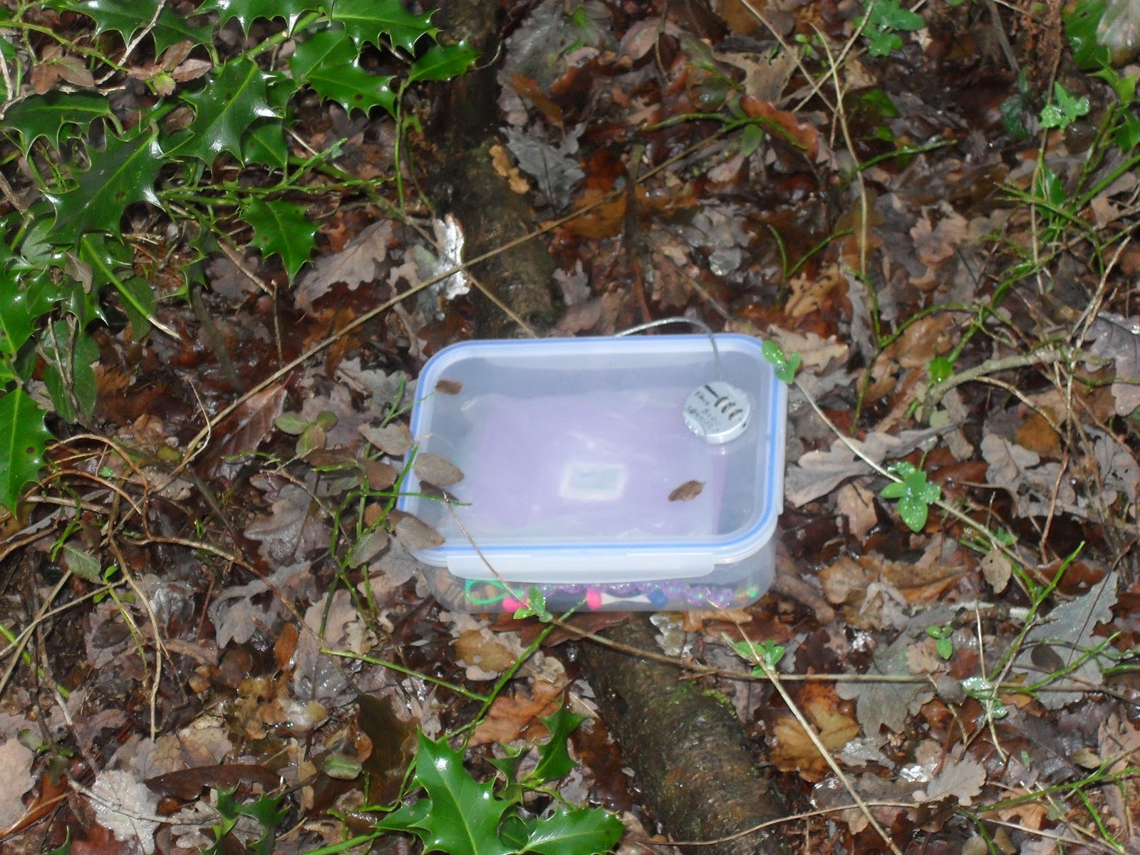
Scene at Cache 2
The cache trail is well thought out and makes the most of its theme - taking you along the quiet canal, along Chinn Brook, around Tritiford Mill Park and then back down to the canal for the return.

I would like to say that you don't know you are in the city.  This would be true, except for the rubbish - which the residents of Birmingham have been using to test the strength of the ice.  I think I lost track of what I saw, but it included
  • A chest of drawers
  • Chairs
  • Kids plastic motorbike
  • Bins bags of bottles
  • All the life presevers around Trittiford Lake
  • The ubiquitious Shopping Trolley
  • Pants
  • Socks
All a bit depressing really.

The caches were very amusing - especially number 2.  I looked hard and found something that I instantly dismissed.  Gave it up as a DNF and slipped/slided away only to reconsider with a "What If".  I was returned and was rewarded!

There were a higher than usual list of DNF or Did Not looks.  The snow was still quite deep in places and in respect to the detritus, I was not going to stick my hands in some places.

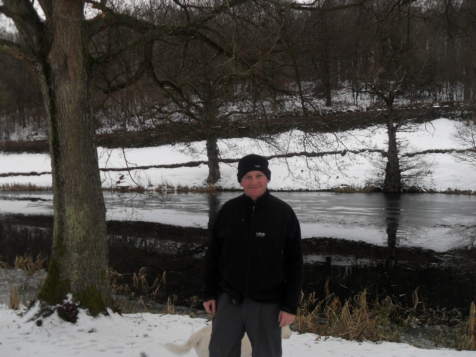
And the 1000th cache - if I got my counts correct, it was Number 10 by the lake. http://www.geocaching.com/seek/cache_details.aspx?guid=53ec1a71-5a06-4924-9d1b-87f10876baeb

Cue Fanfare - Cache 1000
So I achieved my goal by doing two rounds over xmas that couldn't have been more unalike.

The goal for 2011 - I think I am going to concentrate more on the walks than the caching!  I have been going after these big rounds of caches to keep the numbers up and I think I would like to concentrate more on the locations and quality of walks next year.

And do 100 in a month!

Thanks to the gogetters for setting this up.  Especially Cache Number 2 - that made me smile!

Monday 27 December 2010

27/12/10 - Devauden Round - Annual Visit to Tintern

Walk length - 5 Miles
Number of Caches - 18 + 1 Bonus
Starting Cache - http://www.geocaching.com/seek/cache_details.aspx?guid=aa9796b0-7cc9-460b-a3c4-025478f9818d

Fifth year on a row that I have been down to Tintern at Xmas time.  Wasn't sure what the weather would be like after 10 days of snow in the midlands and -17 temperatures.  The thaw is starting today, so rather than a traditional walk from the Abbey, I decided on a round of caches about six miles way at Devauden.

This is a short trail across farmland and in woods with expansive views across the Wye Valley.  Mr Jackoboy is obvioulsy a man with a sense of humour, as the caches were often in unusual containers - inlcuding a rubber rat, several hollowed out logs, drilled into a stone and a personal favourite - under trick dog poo - although I am not sure that bodes well for future hunting.

Parked up by the river and headed out in order, up the green lane past the church to take in 1 and 2.  Met some dog walkers at Number 3, so had to admire the view.

Nightendale Cottage View
Could tell that no-one else had been this way for a while, as I had virgin snow on the descent.  The snow made many of the caches a challenge, as they required digging out.  Fortunately, the clues on this series were all very specific.

Virgin Snow
Continued across farmland, where some hardy sheep were out in a couple of fields before getting to Ledw pool and finding somewhere to balance the camera for a self portrait.


Been going steadily downhill until this point, so have to climb back up, eventually into Chepstow Wood Park.  The caches get more dificult as the snow is deeper but the more interesting recepticles are now in play.... This is the highlight of the walk, not least for the old fella trying to ride a mountain bike through 6" of snow.

Get back to the car and then drive down to the Abbey for a look and record the ice flows, as the thaw has defrosted the Wye.  What a winter!


Henry the VIII - Wife murderer and lead thief from Abbeys.


I shouldnt have been surprised the downstairs Khazi froze up - Icebergs on the Wye.
So a stunning walk and I get closer to the magic 1000 caches.  Then I can retire.  Thanks to Mr Jackoboy for the well thought out and maintatined cache trail.

Saturday 18 December 2010

17/12/10 - Tarn Hows

Distance - 7 Miles
Geocaches - None.

After the excursions of yesterday, we have a low level walk today.


Can you guess where we are?

This takes in the edge of coniston water and then heads up through woodland to the impressive Tarn Hows.  This is a series of man made lakes that sit in the middle of incredible views of distant hills.  Wish I could recognise more than Coniston Old Man that we climbed yesterday.

We walk around the lakes, completely frozen, and then head up for Torver intake for even better views...

Backdrop, on Torver Intake
We walk back down around Tom Heights (thankfully not climbing them today), to pick up the cumbria way, returning us to the town. 

A nice gentle one, after the excursions of yesterday.

16/12/10 - Coniston Old Man

Walk Distance - 8 Miles
Geocaches - 1 (Rocket was cold) - http://www.geocaching.com/seek/cache_details.aspx?guid=6ca53a56-78c5-48ef-b2a2-7424b6c11806
Weather - Blizzard, followed by clear skies, sunshine and views to die for
Number of pints - 9 (we lived at the Coniston Brewary and got there at 4pm).

Company today.  We had arranged a two day walking experience about 6 weeks ago, before Britain was gripped by the new ice age.  It was touch and go about whether we went, as there were concerns about getting snowed in and not returning.  As we were living in the world famous Coniston Bluebird brewary, I completed my snow dance to only minor affect.

Our home for the night..
We left Stourport at 6:30am and got there for 10:15.  Last 8 miles were down a country road and it just had to start snowing as soon as we got on it.  It looked like it might be trecharous to get out in th morning.  After spending nearly as long as it took to drive there getting goretexed up, we headed out of the village up Church Beck on the start of the ascent.

Faintly enthusiastic at the start
We continue the climb - not too bad in ascent terms but it does start snowing.  With the wind, I have never seen snow going upwards but this happens.  We make to the eerie old mine workings where I head off for the only geocache of the trip - a nice big ammo box snuggled under a boulder.  Take gloves off to retrieve it and freeze my hands off.  Then realise that the spout to my camel back has also frozen.  This hasnt happened before and indicates problems.  Realising that this might be my only cache, all trackables are dropped off.

Continue the climb to low water - momentary stop in snow and I have a futile look for another cache but even though sandwiches are eaten, the lack of movement means that Rocket starts to freeze up.  So we head on up....


Too cold for caching
In true testing fashion, as we hit the steepest part of the climb to Coniston old man - the path is also frozen, the winds start up so that it blows you sideways and then a blizzard starts that means we cant really see too much either.  Although we were pefectly safe, if we could have heard ourselves over the wind we might have talked our selves in getting to the pub early.  An heroic push fowards got us to the summit and we could see that it would be easier to carry on over the flat expanses of Brim Fell towards Swirl Band.

Thankfully we did, as the snow stopped and the cloud cleared for the most incredible views over much of the lakes, the sea, morcambe bay etc.  The only problem we had was the wind would pick up and snow blast your face.  Hence the red face in later pictures.  This was comfortable, easy walking and a great reward for the efforts of getting here.

They stopped for photos - I didnt leave them...
Swirl band takes you onto Swirl howl for our third and final Wainwright.  It has been slow going, so we miss out Little Carrs, Grey Friar and Wetherlam and after some synchronised luging on our waterproofed trousered arses, we descend the tricky Prison Band.  Rocket leads the way like some sort of wolly hatted mountain goat.  I can only assume he had clocked onto the fact that the pub was open.


Follow me to the pub

We head down a sheep assisted path (like dolphins and stranded mariners, they led the way to civilisation) to Lever's water.

Bonhomie and relief
What followed was a long gentle descent that seemed to go on for ever.... showed how far we had climbed quickly on the early pint of the walk.  We go past the old miners cottages and the YHA - both looking like spectatacular places to stay.

We arrive back in the town at around 4pm - which is perfect, as the darkness is falling.  Check into the hotel and agree to work our way from left to right on their real ales.  As our water froze, we are generally in need of fluid.  4 pints before we get changed for the night and head out to see what the night life of a Lakeland village has to offer.

Saturday 11 December 2010

11/12/10 - Fairfield Round - Hunter's Walk Part 2

Number of caches - 15
Starting Cache - http://www.geocaching.com/seek/cache_details.aspx?guid=26a2b27f-7f8f-4f94-a676-a98ef5176996
Distance - Around 5 miles

I completed the first wave of Royal Hunters Walk in September (http://mappiman.blogspot.com/2010/09/11th-september-royal-hunters-walk.html) and have been looking forward to this new, sister route since it was published a couple of weeks ago.

Parked up at the suggested place and saw a couple of walkers getting out of their 4x4.  I wondered if they were cachers.  Decided to leave a bit of a gap and see if they were on the same trail and sure enough, as we descend to Cache Number one, the gentlemen throws himself to the floor to receive Cache Number 1.  I decide to change the order of the route, starting at cache 5 and leaving a "Hello" note in cache 15 to the Stag Ramblers.

So, caches 5 and 6 are out in country fields..... leading to Pepper Wood which is the highlight of this walk.


Home of many caches.
 Most of the caches on the trail are in the woods and part of the fun is finging the paths to get to them, as they are not marked on the O/S Map.  Fortunately, I didnt take any wrong turns and completed them all in order.

Cache 8 (http://www.geocaching.com/seek/cache_details.aspx?guid=2acecd57-699c-47cd-b517-25a682ea51fe) is the highlight of the round.   I was expecting the container, having seen a couple on the first round, but this is the first time I have had to turn safe cracker to get in and sign the book.

Padlocked Cache
Continue through the woods before skirting back around farmland to the start of the trail.

Caches 1-4 are in fields, where the footpath has been diverted for some huge excavation that is going on - never got to the bottom of what that was.  Some surprsing cache containers which really do summarise the amount of work that has been put into this round.

Leave cache 15 till last - this is another first for me - one at a football stadium!  No game on by the time I got back, but I believe there was one later in the day.

Looking at the logs, there have been 5 other cachers out on the same day.  I think the relatively balmy weather and great series would mean that they all enjoyed it as much as me.


Almost as many logs as I had to complete after the walk


Thanks to the Bailey Rangers for setting this trail up.... A highly recommended series.

Saturday 4 December 2010

4/12/10 - The RQ Series near Romsley

Number of Caches - 8 and Bonus and an outlier
Distance - 4 miles
First Cache - http://www.geocaching.com/seek/cache_details.aspx?guid=36cea992-3cfa-4493-b784-0fbd83478da7
The bleak start - it gets better when it starts raining.
After four days in London for work, I want to get out in the countryside and don't let the weather put me off.  There have been three new series setup in my local area, so this will keep me busy until the end of the year.

One of them is a new series in Romsley - four miles and nine caches, in the woods and fields between the m5 and halesowen.  I park up at the layby near cache 1, only marginally concerned about whether I will be able to get out of the snow at the end.

The above picture shows the lack of view.  Head down the Monarch way, which provides good paths, especially through the woods.  The caches are all pretty easy to find, which is fine for me in this weather.  I dont want to be hanging around!

After RQ 1 to 4 - There is an outlier cache, http://www.geocaching.com/seek/cache_details.aspx?guid=d0b048ea-d80b-4d91-9ad7-2e3ad0c61669, which has a nice story.  I have walked here before and wondered what all the brick foundations were.  Have a look at the cache for a photo revealing what it was for and why it went.

So thats what these are for!


After this one, I start the walk back.  I should have put the bonus co-ords into the sat nav, as I end up walking past it.  More careful reading of the description would have revealed this to me.

The sheep come out at Cache 6 to provide some advice....

Helpers
And look out for the hidden place watching over Cache 7!

Protecting the cache..
So, missed out on the bonus, but I will come back at some point to complete.  Thanks to Lime Candy for setting up another nice route.

Saturday 27 November 2010

27/11/10 - The Lenches in the Snow

Distance - 11.5 Miles
Number of Caches - 26 (24 found)
Starting cache - http://www.geocaching.com/seek/cache_details.aspx?guid=8596ba45-5497-4ae8-860c-29058af41868

I have been looking at this round for a long time and the spattering of snow didnt put me off.  Park up at the churhc in Rous Lench.... pay careful attention to whether or not its a bus stop or not.  Head up for the first and then down a green lane.

Snowy Lane out of Rous Lench
From a walking perspective, Yeald Woods are the highlight of this walk.  I can here a loud snapping noise and when I cross the field to the woods, I can see it it a man snapping a plastic sheet to make the pheasants fly up.  As I get closer, he asks if I could put the dog on the lead - presumably in case they scare the birds.  Country folk with their country ways!  To be fair, as I enter the woods, there is a sign to get the dog on the lead and I always follow the instructions.

Good walk through the woods with four caches before Church Lench - which is the next hamlet we reach on the walk.

Easy to know why its called Church Lench
Continue down the Wychavon way for a couple of DNFs - the first, I have no idea.  The clues have been spot on on this trail and many of the caches are quite open - but I just couldnt find what the clue was referring to.  The next for http://www.geocaching.com/seek/cache_details.aspx?guid=ccb74638-b845-4bc8-bbc5-c3c162472dd1 I think may have gone, looking at the gallery pictures.

Zig Zag down through fields until arriving at Craycombe Cottage - lovely lodge houses here and great views of Brendon Hill on the other side of the River Avon.


Work my way back up to Bishampton - the trail takes you around the back of the only pub on the trail!  I really should have taken a detour here, as I have been out for around 4 hours - but I am probably too dirty anyway.  Find one of the caches outside its nifty holder - put it back and hope it doesnt ping out again.

Then its a case of heading back in a North Easterly direction to the car.  Pick up the remaining five caches in fields and common land.  Total route took me exactly 5 hours.  Dog doesnt move for 24 hours after we get back.

A well thought out trail - at all major route decision points there is a cache to help you make up your mind.  The caches are all pretty easy, which on a route of this length is exactly what you want.  All caches are in good condition and I have added TBs to Lenches2, Lenches10 and Lenches15.  Thanks to Tarmacjohn for the setup and maintenance.


Somewhere around Cache Number 21. If only I could get the dog to look in the correct location!

Saturday 20 November 2010

20/11/10 - Trying to get to 900 in Hopwood

Length of Walk - 6 Miles
Number of Caches -
First Cache - http://www.geocaching.com/seek/cache_details.aspx?guid=0f1ed52f-5849-44f7-8fbb-ab9387259ddc

Horrible, foggy morning.  Its not raining but everytime there is a breeze, it blows great big drops from the trees - the sort that drop straight down the back of you jacket.

There are a load of caches in this area - a trail of Studio 16 - named after Stranglers albuns - a smattering of other in the Wast Hills.  I am 11 shy of my 900, so head out hoping for success.  I dont quite make it, thanks to 3 DNF!

Struggle to find somewhere to park down the narrow lane.  At one point, I am parked in the Autism Centre but then notice the private property sign and the fact that the barrier has a lock on it.  Move the car to a layby further north - which has a borders bag full of erotic fiction for ladies.  Bizarre.

The first cache is directly over a canal tunnel.  I dont realise this and am looking for a path on the ground.  Closer inspection reveals what the OS Markings on the map mean.  I am a duffus.  Find the cache and then drop off a TB.

Continue west for a find and then a DNF - I am looking for something at Waist Height but only spot barbed wire and brambles.  Continue on to a nice looking Pub called the Peacock, which has a cache over the road.

I then start on the Studio 16 Series, with 2 DNF.  The first at Yew Tree Farm.... next to the road, you think the passing motorists are mocking you and then down the world's muddiest lane - where a horse joins in the mocking of my futile attempts at searching.

At http://www.geocaching.com/seek/cache_details.aspx?guid=526764d8-1f80-4fe8-b270-16760205851f i realise why I am having trouble finding the studio 16 caches... they are tiny!  This one has a decent clue, so I find it OK.

Before I know it, I am back at the peacock and make a pointless diversion across a muddy field to get a cache buried in the ground, but roped to a sign!  I have nice dirty boots with Pizza sized plates of mud in a circle around them!  Still, gets me one closer to the 900.

A bit of popping down lanes already walked, as I am walking back towards the car where the scenary takes a highlight as I walk down a wider expanse of greenery for two caches.  Couple of nice looking residences, I think one is Forhill House.  You wouldnt think you were a couple of miles out of BRM here.

http://www.geocaching.com/seek/cache_details.aspx?guid=526764d8-1f80-4fe8-b270-16760205851f is the last of the walking today.... there is one more that I could have got but it would mean another muddy yomp through ploghed fields... I'll save it for the Summer!

Stop in the car at the m42 services for a cash and dash.

So found 9 which leaves me on 898!  I think I will get the 2 needed for 900 when I am in St Albans on Monday night... must remember my head torch!

Thursday 18 November 2010

Is this the greatest device ever for caching?

Glofiish X800
I have always used PDAs for caching but in a effort to carry only one device with me, I got hold of this Windows Mobile phone with GPS of Ebay.

First things first - the GPS is deadly accurate - never any spikes or random jumps around - always spot in.  Even in London.  This makes finding nano's easier.

I can run cachemate for a downloaded list of caches in the area and can log my caches, if I have 3G or a Wi-Fi in the pub, I can log the finds in the field.

But the greatest feature - as put to use in Harpenden last night - it has a torch on the back!  And it works pretty well, enabling me to go down a pitch black footpath and find a 35mm cannister behind a gas main!  How good is that.

If only I could get a signal at home, it would be perfect. 

Tuesday 9 November 2010

7th November 2010 - A new round outside kiddy

Miles - No more than 3
Number of caches - around 8
Number found - 1.5 on day one and the other half on day 2.
First cache - http://www.geocaching.com/seek/cache_details.aspx?guid=74ab0fda-e33f-4e72-9892-9c5b0dd76913

If you like a challenge, then I recommend this cache trail that has just appeared outside of kiddy.  There are no clues, apart from the titles that are anagrams.  I am useless at anagrams, so had a less than successful day caching, but I did enjoy it.

I particulary need to tell you about the experiences at http://www.geocaching.com/seek/cache_details.aspx?guid=5406c71b-cab1-4ad5-bc42-3719c268bb73.

The first cache at the parking layby completely baffled me.  I then moved on the star of the show.  I could guess where it was, but it looked like it needed special equipment.  My attempts as dislodging with a very large branch were futile.  Fortunately, I had the glen to myself, so no-one saw.

After following the trail and finding only one, despite deciphering at least one anagram, I returned home and enlisted the help of my son.  He wanted a new game for his PS3 - so he owed and due the fact that we needed ladders, we retuned on 9/11/10 with the appropriate kit, under the cover of darkness.

Hi Ho - Its off to work we go!
A short but muddy walk brings us to GZ and then up persiscope and send the boy up to retreive.

I'll do anything for a PS3 Game
He chucks down what I was poking with a stick on Sunday and lets just say that it turns out not as expected.  More hunting required, but eventual success and I have the TBs to prove it.

As I say, this trail is not your normal run on the mill series and I think the remainder will keep me occupied for a number of weeks.

Thanks to FungimanForager for setting them up and sending an email to all the hunters over the weekend, explaining the raionale behind the series!

Saturday 6 November 2010

6/11/10 - The Gentle Cotswolds around Stow

Distance - 6.5 Miles
Number of Caches - 11
First Cache - http://www.geocaching.com/seek/cache_details.aspx?guid=1d00b8f8-98f1-4ae2-ad25-47c99aa90fa5

I love the Cotswolds and have been walking here since I bought a dog 8 years ago.  Four years ago, I completed the Cotswold Way (with Dog) over the course of two long weekends.  I am now re-discovering areas, since taking up caching two years ago.

I have had my eye on the Swells and Wells round for some time and a couple of months ago, I even took in a couple on the Sezincote Stroll round completed.  Today, i am here again.  I think that parking might be tricky in Stow on the Wold on a Saturday, so I see a sign for Upper Swell as I approach from the North and see if I can park here.  The answer is yes, at a Sewage Farm's wide entrance.  It means cache number 1 for me is number 4 on the route.

What I like about the Cotsolds in its English Charm, pubs and gentleness.  This is summed up by the view that you see on the first building of the day which says "Beware of the Dogs".

Unscary Guard Dogs...
Head on up the hill and find the first cache of the day, which also shows me where the Donnington Brewery is.  I have had a few of their pints over my walks in the Cotswolds.

Home of Donnigton Beer
Carry on up hill, easy cache between trees and then over the main road, so the dog can come of her lead for the first team.  Soon, I am on familar ground again, as I take up paths that I walked two months ago on the Sezincote round.  Means that I am walking for a while in great countryside without caches until I get to Broadwell.

This is a lovely village and if I had a horse, I would have been tempted to ride to see if they could be bothered to levy the fine!

What sort of deterent is this!
Here, I record a DNF, as I fail to locate a cache at the back of a phone box.  Made more tricky, as it is adjacent to a ford and the cars slow down to enter.

Never mind, I continue up a lovely green lane on the Monarchs way for a couple of caches until I reach the outskirts of the Stow on the Wold.

This is a stunning location.  One day, I will come and stay overnight and allow myself more time to go in the book shops, teashops, pubs and explore the intricate alley ways.

Stow - take your time here
I take a detour from the Swells and Wells series to find a church micro.  This is not too easy as a) it looks out over a perpetual traffic jam at the lights and b) its buried under the leaves that some proud Citizen has kindly swept up!

Over the road and across fields to take on the last three of the series.  On the map, it looked like a bit of road walking here, but there is a permissive path on the side of the road.  Before long, I am back at Upper Swell and glad to see the car in one piece.

So, the cache tally increases through another Wrighty Round in the Cotsolds.  Thanks for setting up, and the recent maintenance.  I will now be monitoring the Broadwell cache to see if that is found.

Sunday 31 October 2010

31/10/10 - New trail in Peopleton

Distance - 4 miles
Number of caches - 8 and 1 Bonus
Starting Cache - http://www.geocaching.com/seek/cache_details.aspx?guid=06052431-9623-453d-be83-783e707bcb45

Back from a week's holiday, getting in at 2am.  Maybe it was the jetlag or maybe it was the cold, but I am up at the crack of dawn and logon to see there is a new trail layed in the village of Peopleton, around 15 miles from where I live.  Just the inspiration that I need, so I run a Pocket Query and pick up the labradoodle from the sitter and head off.

The only problem with new trails is that everyone has the same idea.  I meet cacher party number 1 at cache 2, lone cacher 1 at cache 3 and cacher party number 2 at cache 4.  What is etiquette here?  I always say hello to people that I meet, but when you are on a circular trail that both parties are following, do you really want to be walking around with a stranger for 4 miles?  I decide probably not and spend a fair amount of this trail lurking behind trees and rounds bends in path corners!  No way for a 41 year old to be spending his Sundays.

Think I meet some serious professional cachers - by the clues found on this car in a layby.


Geocaching.com Car.

Cache 1 is at a Mill House - literally at a house.  With people in the garden.  So i decide to give this a miss.

Caches 2-7 are between Peopleton and White Ladies Aston.  Flat countryside with extensive views and Wolverton Hall grounds to walk through.  Caches are all relatively easy finds - Number 7 has the co-ords for a bonus and number 8 is a very nice location - at a ford, with a right hand fork.


Loved by 4x4ers - The ford at Barrell Bridge

These green lanes are also popular for 4x4'ers, as I have to give way to they souped up 10 year old trucks on three occasions.  It must be the thrill of going through the ford that brings them here.  I get the same experience by sploshing through their water filled tyre troughs.

Return to the village and the bonus is in a fantastic place.  This didnt come up in my PQ, so I can only assume that it was not yet published - still, with the name and spot on co-ords, it was soon in my grasp.  Just as the heavens opended.

So, nice walk, nice trail, nice caches.  Thanks to the owners "Jayvon" for taking the trouble to set up the series.

Tuesday 19 October 2010

17/10/10 - Nottingham City Centre

Normal walking and caching has been cancelled this weekend, due to a visit to Nottingham to catch up with old friends.  Stay in the hilton in the City Centre..... OK once you have parked.

After seeing our friends, my major requirement was to visit Ye Olde Trip.  Everytime I talk to anyone from this City, I ask them about this place.  I guess its because I am a regular in the fighting cocks in St Albans, which also claims to be the oldest pub in England...  The pub was excellent - loads of nooks and crannies and dead ends, which meant my exploring was increasingly embarassing as I walked into small rooms full of people with no exits.  The beers were good and there was one cache just outside, which I found on the Sunday.

Also found the other cache at the top of the hill by the castle - which means a 2 cache haul when sneaking out the hotel and leaving her indoors, indoors.

Englands Oldest Pub?  Dont Tell St Albans....
If I came again and had the time, there are a lot of caches down by the river in the east of the City.

14/10/10 - Hammersmith to Kew Gardens

Walk From - Andrew Duncan 50 favorite walks
Number of caches - 6
First cache - http://www.geocaching.com/seek/cache_details.aspx?guid=6bb92e8d-903c-4b0a-b858-abf73371831c
Distance - 6 Miles

Stay in Hammersmith - the Bridge is the natural start of this walk, but I started at the Novotel Conference Centre - which was hosting some sort of Media conference, mainly populated by septics.

Hammersmith is an impressive bridge - looks like the golden gate - and has a cache slap bang in the middle.


Theres a Cache here
The the walk heads up stream, following the thames path.  There are some excellent looking pubs at the start of the walk, but I dont want to go in to early.

The caches on route are mainly 35mm pots or key safes - attached to signs, stuffed into the railings, on the back of road signs and impressively, 7ft in the air under the tunnel at Kew Bridge!  All reasonable to find, even in the dark.  There would have been more in Chiswick Park - but it closes at dusk, so 8pm in October has no chance!

Highlights of the walk were when I came up from the river at Powell's Walk, through a church yard and up into Chiskwick...... at night, with its victorian lighting, lent itself to an atmospheric walk.

The strand on the green is a nice area...... the cache outside the Bulls Head is worth an attempt - complete with a decoy.  I couldnt find on first go and had to go in for a pint of inspiration in the flavour of Timothy Taylor Landlord.  Easy find when I got out!

Then stopped at the City Barge for something to eat... probably made a mistake, as the food in the Bulls head looked better.

Then down to the bridge at Kew, crossing over and getting to the train station before my journey back to the hotel.

Cant really go wrong with LDN river walks, but this was especially quite - had most of the walk to myself.  Some people live in fantastic houses as well....

Saturday 9 October 2010

9th October 2010 - Badger Round

Number of Caches - 14 in route (found 12 today, having already had one and missing one)
Starting Cache - http://www.geocaching.com/seek/cache_details.aspx?guid=948c2cfb-4cf4-44c2-ad5f-027132f8ab2d
Distance - Around 6 miles...


Hunter's Bridge

Duck Pond at Start of Walk
There are two cache trails layed by the same people (thank you Lost and Found) that actually meet up - so you could have one full day or two half days.  I have already completed the Beckford round, so came back into the area to run through these at Badger. 

The caches are easy to find, thanks to great clues and spoiler photos.  But don't be misguided - the paths are very hard to find on both routes, many of which arent on the O/S Map.

The first cache of the badger round is at the church.... I then moved onto number 2 (already found last time out) and number 3 by going along "the chase" path.  In October 2010, parts of this path are closed - with a big sign announcing "badger activity"  - oh the irony.


Footpath closed
 I manage to go around by sticking to the field edge.

This series of caches in not circular and you will have problems trying to get around all of the them without repetition.  I managed an awful lot of repetition on this one.  Started with Number 4, where I dropped of a TB and then a bit of road walking before a bridle path to number 5.  Not confident that the beasts in the field have udders.

Mouthy udderless teenage beasts
 

After surviving what could have turned out to me the Shropshire version of Pamplona, I get an tricky find at number 11 and then an interesting backwards and forwards attempt to clean up 3 on map unmarked paths.

If you are reading this before doing the round, pay attention - it may help!  Take the path number 12 - this is by sandstone paths and down towards the water - although this is so steep that I wouldnt recommend it after rain if you want to get back up.  Of course, it had been raining when I did it, but I need the numbers.  Continue along the path, but keep your eyes open for what looks like a cave in the sandstone - go investigate, its actually a path through which you need to take if you want to get number 13.  Most unexpected, and you also get the first of two temples on route.

a cave that has holes at both ends is a tunnel

Temple 1

You should then return on the high path, if you want to pick up number 14 - there is a discarded half vodka bottle that will identify the tree that the cache is behind.

I then had a circuit of the pooled Wharfe River to pick up three more caches and, going past the second temple which someone has converted into a type of summer house (who lives in the woods like this?).  Return to Hunter's Bridge for my final one, but on logging this, I can see that I missed number 7!

Very enjoyable trail  - Thanks for the owners who have put it together!

Saturday 2 October 2010

1/10/10 - Blencathra Round

Distance - 11 miles
Geocaches - 2
First Cache - http://www.geocaching.com/seek/cache_details.aspx?guid=22bc13ce-af4d-46b0-9e68-24a76cc0f06d

No photos today - took camera with me but there are no views, with the exception of horizontal rain.

Start at my pub - the Mill Inn.  Superb food and beer and a stonking breakfast, which means I waddle up the road and then up Souther Fell at a slow pace. 

The heavens open and the mist comes down - there are occasional glimpses of exceptional views on the zig zag path up Blencathra but on the whole, its a very miserable day.

I was going to go up Sharp Edge, but there is no chance today.  I would have been blown of this exposed arete - probaly all the way back to the car.

Rest of the walk is increasing misery, although I am out of the wind, if not the rain.  Mungrisdale Common is not really a peak - Bannerdale Crags would have had decent views if it wasnt for the mist and Bowscale is notable for its near vertical descent back to the road.

Saw one man with his dog - have my feet ripped to pieces through new boots which were tested ok last week.  Maybe it was the half pints of water that I tipped from them that soften my feet up to allow the blisters to come.  Rucksack is equally soaked - thought my camera might have been ruined - but remarkably resistant.

On the plus side - its the last 5 wainwrights of 2010 and I did get another couple of easy caches.

Somewhere more gentle next weekend I think.

30/09/10 - Carrock Fell and High Pike

Miles - 6
Geocaches - 4

Using up a the last of my 2010 holiday allowance, I head up to the lakes for the last time this year to knock off a few wainwrights.  Today, I complete Carrock Fell and High Pike, following the route in CW Magazine in Sep 2006.

Park up by the side of the path up - which is barely visible and stupidly steep.  Desolate starting place, as shown in the photo, I have the place to myself.


Starting Point
Quickly (although stop for many rests) gain height until I end up on the decent peak - complete with Cain and a cache.  The only person I see all day is approaching from High Pike, so I have a quick route around to find the cache, which has the handy clue of "under a rock".  In a field of rocks, this is less than useful!  Eventually find and am rewarded with a TB.

Nice views from the top....


View fro Carrock Fell

With the height gained, its an easy walk across to High Pike across some boggy ground on a indeterminable path.  Mess around with the camera on auto settings for a self portrait, with Carrock Fell in the background.


On High Pike, with Carrock in the background
Path down to the road is quite straightforward - there are three caches at ground level, one hanging from a tree, one under a boulder where the car is (forgot to get at start) and one a short drive at Mosedale Bridge.

Good walk today - 2 more wainwrights knocked off and good weather.

Stayed at the Mill Inn - top, food and the starting point for tomorrows walk.

Saturday 25 September 2010

25/09/10 - Englands Smallest AONB

That's Area of Outstanding Natural Beauty.


Cannock Chase
Walk Length - 9 Miles
Number of Caches - 4
Starting Cache - http://www.geocaching.com/seek/cache_details.aspx?guid=cb5c02a0-28a8-48b7-bc81-7560dfdabda5

This has been chosen for the walking, rather than the caching and what a great walk.  The route followed was from an old country walking magazine (Sep 2004).  I have been buying this magazine and database the walks, so that I have walks ready for any part of the country.  If any one wants a list in Excel or as an Autoroute overlay, then drop me a line - I have practically all of them.

The Walk was in two halves - the first was south from Seven Springs Car Park (no sign of Stan Collymore, although there was some suspect litter) and heads south on fantastic paths.  A real place of isolation - within 20 miles of Wolverhampton.  Who would have thought it!

Abrahams Valley takes me past the inappropriately named "Hell Hole" for the first cache, which is at the bottom of strawberry hill.  I disappear into the bushes, just as a woman comes past with her dogs.  One of the dogs has a dead pigeon in its mouth, which enables me to talk about that, rather than what I was doing.

The paths are excellent and deserted.  Great views.

Molly on Abrahams Valley Path
The path comes around to Sherbrook Valley path.  This is great walking, next to a clear water stream, pulling up to Stepping Stones and then Milford.

Stepping Stones
Cross the road and my walk takes a different perspective, following the Staffordshire and Worcestershire canal over the River Trent and back down to Seven Springs car park.


Tixhall Lock

Aqueduct over the Trent
Canals are always great for caching - but retrieval can be tricky.  At various stages today, I was interuppted by boaters, walkers, cyclers and the ubiquitous pseudo tramps with Special Brew.  Today there were three and one shook my hand.  I think that I collected the full set.

At one stage, it looked like the staffordshire pirates had scuttled a barge.  I have seen these sorts of scenes with abandoned cars, but never a water based wreck.

Police Aware
Canal walks are flat and undemanding, but always have the possibility of pubs/cafes to stop at.  This one no expecption, although I have no cash with me.

Return to the car.  Enjoyable walk in great weather.  Only trouble is with M6 traffic, it took me twice as long to get home as to get here.